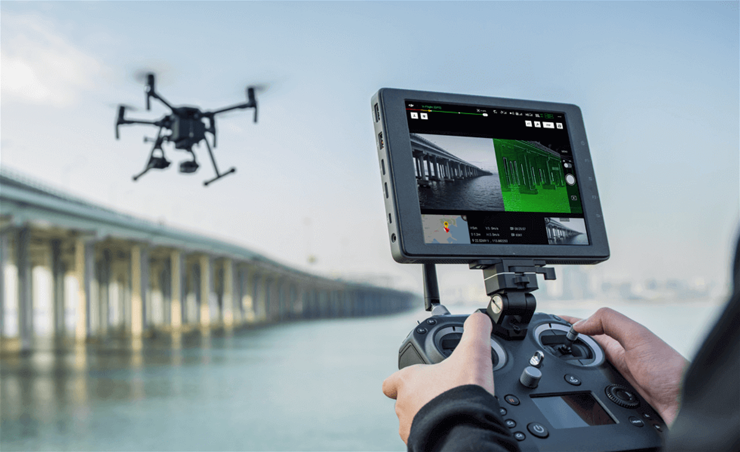
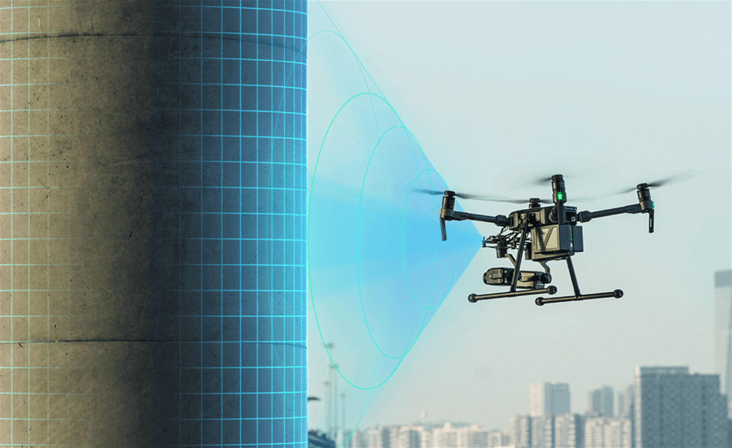
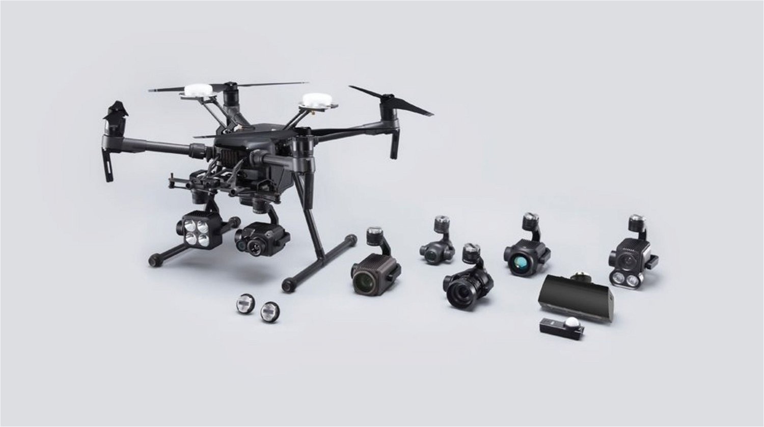
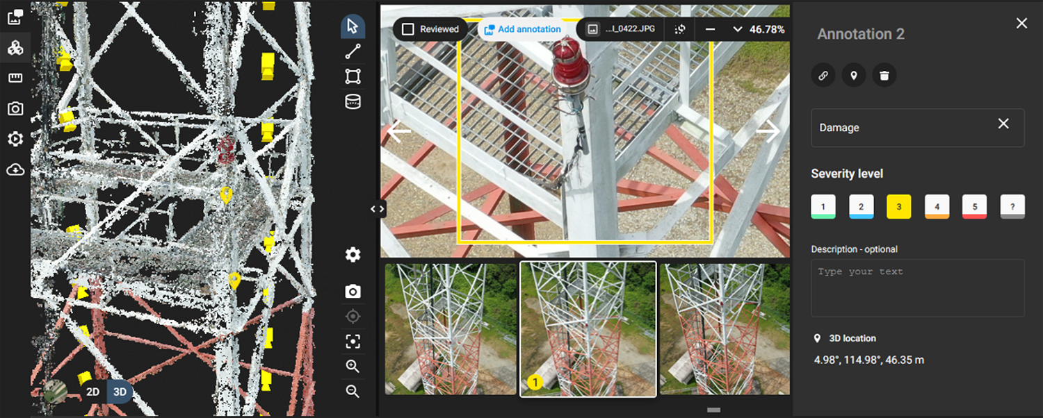
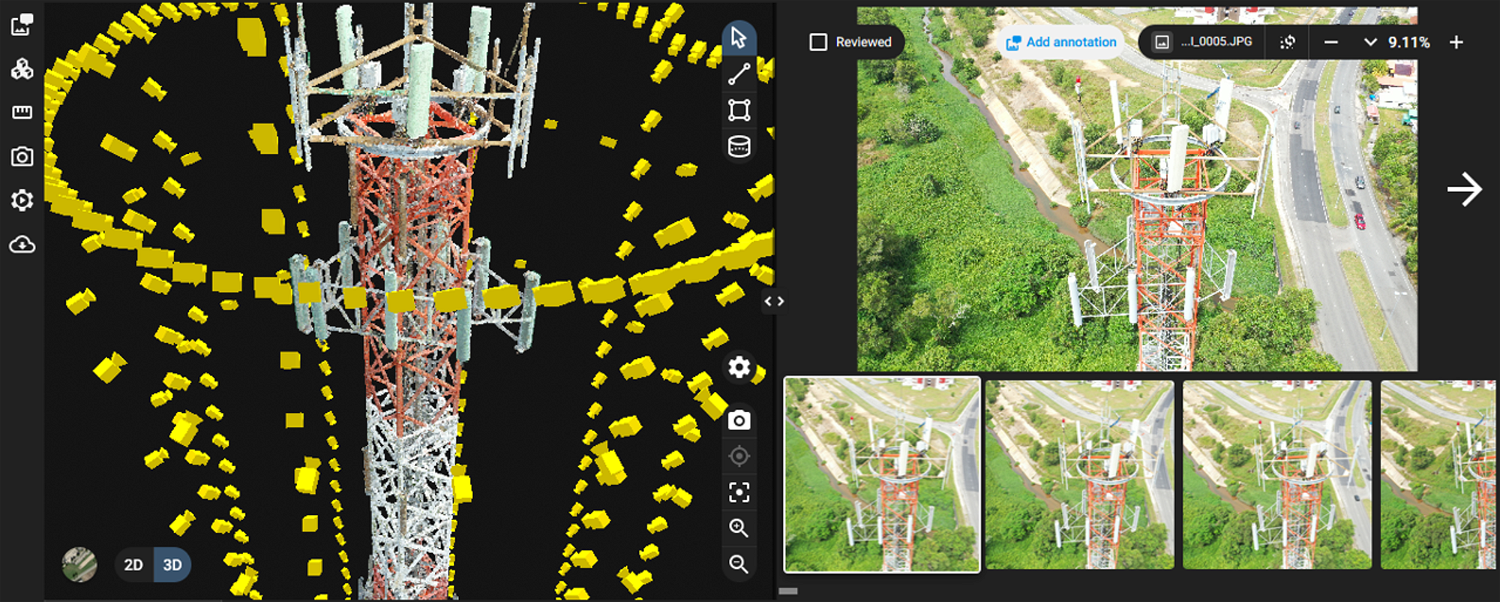
π Collect visual data of your asset
Drones are fast becoming a critical part of the overall asset management solutions. It allows personnel to perform inspections from a safe distance, without using expensive ladders or scaffolding, and while remaining completely safe from falls. Using drones, large areas can be covered in much less time, even for more complicated inspections such as thermal imaging. And in the case that maintenance or a repair is needed, the technician can arrive at the problem location with a fault diagnosis already in mind.
π¨ The Power of Technology
Our drone attached with the Z30 sensor is the most powerful integrated aerial zoom camera on the market with 30x optical and 6x digital zoom for a total magnification of up to 180x. Whether you are inspecting cell towers or bridges, it enables you to get a detailed look at structures, wires, modules, and components to detect damage. The camera also has a TapZoom feature that makes zooming in and getting an enlarged view of a specific area as quick and easy as tapping your finger on your monitoring screen. As a result of letting you conduct inspections from a distance without the need to fly close, not only is the speed and efficiency of your operations increased but the risk of collision is obviated.

Β
Drones have become an essential tool in power line inspections by providing transmission network managers with crucial data to make informed decisions. Our industrial RTK drones are immune to interference to allow safe flight. Zoom lenses allow high detail of the power line ad all its components such as cross members, phase conductors, insulators and missing bolts.
Β
π» Manage Your Assets Remotely

Β
Reshaping asset inspection forever
Safely and efficiently gather inspection data from the air for building and assets much more economically than traditional methods. A close visual inspection of your asset provides invaluable knowledge to assist in analysing the condition. Once the brief is finalised, the correct remotely piloted aircraft and payload are selected which is then matched with a team of operators who are skilled in that area. Frequent inspections can detect change over time and highlight problem areas before they become an expensive repair job.
Β
If an inspector finds an issue that requires maintenanceβwhether the problem is discovered with a drone or through some other methodβthe subsequent repairs will still have to be done manually. Drones are simply an additional tool in an inspectorβs toolbox.
Β
Β
Managing Assets with a Drone and Data Driven Solution
In many instances, a drone inspection will be a visual inspection, with the droneβs camera acting as the inspectorβs eyes. Using a drone, visual data is collected and then reviewed in detail later by the inspector (some review is done on the spot too but the thorough inspection is done after the data is collected). By sending a UAV into a situation that would be dangerous for a person, inspectors are able to collect visual data about the condition of an asset without having to expose themselves to potential harm.

Β
We can provide a physical transfer or a digital handover of the images & video via a web link which the client can download. Although, on request we are able to live stream the video online to clients if they need an immediate report. We also offer 3D modelling of infrastructure that has proven very useful for clients.
Β
π§² Non-Visual Inspections

Β
Β
While itβs true that most drone inspections are visual inspections, with the drone simply taking the place of the inspectorβs eyes, drones can also be equipped with special sensors that allow them to perform other kinds of inspections. Basically, any kind of sensor that can fit on a UAV can be used for an inspection, whether it be thermal imagery, NDVI sensor, and more depending on the needs.
Β
π₯οΈ Platform-as-a-Service
Depending on your needs, we are also able to provide an integrated platform allowing you and your team to safely inspect and manage your assets remotely, annotate any issues to notify the asset maintenance team, with accurate location, and view a 3D digital twin of your asset.


π‘ Why Choose Us
π High Quality
By using professional-grade equipment, we are able to collect high-quality images that provide you with a clear and detailed view of the condition of your asset from all angles and elevations.
π» Expertise
Our experienced team of professionally trained and certified drone pilots and data analysts ranging from various industries can help to supplement your business operations.
βοΈ Get in touch
Interested to learn more about this service and pricing?
Send us a message through the contact form and we will get back to you within the next working day.
π© Contact Us
Unit 13, Level 2, iCentre,
Simpang 32-37, Kg. Anggerek Desa,
Jalan Berakas, BB3713,
Bandar Seri Begawan,
Brunei Darussalam
Β
π Working Hours
Monday to Friday
8:30 AM β 4:30 PM
π Our Services
β½ Oil and Gas
ποΈ Construction Survey
π» Internet of Things
πΉοΈ Augmented & Virtual Reality
π Other Drone Services
Β© 2022, InnovAero Sdn Bhd. All rights reserved.